

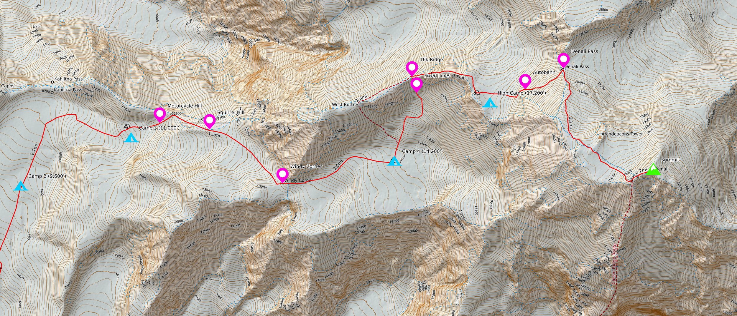
2022 Denali West Buttress

On May 8, 2022, Sam Nofziger, Ethan Bouvet and I flew out of the small town of Talkeetna and onto the Southeast Fork of the Kahiltna Glacier to begin our ascent of the West Buttress of Denali: the tallest peak in North America standing at 20,310’.
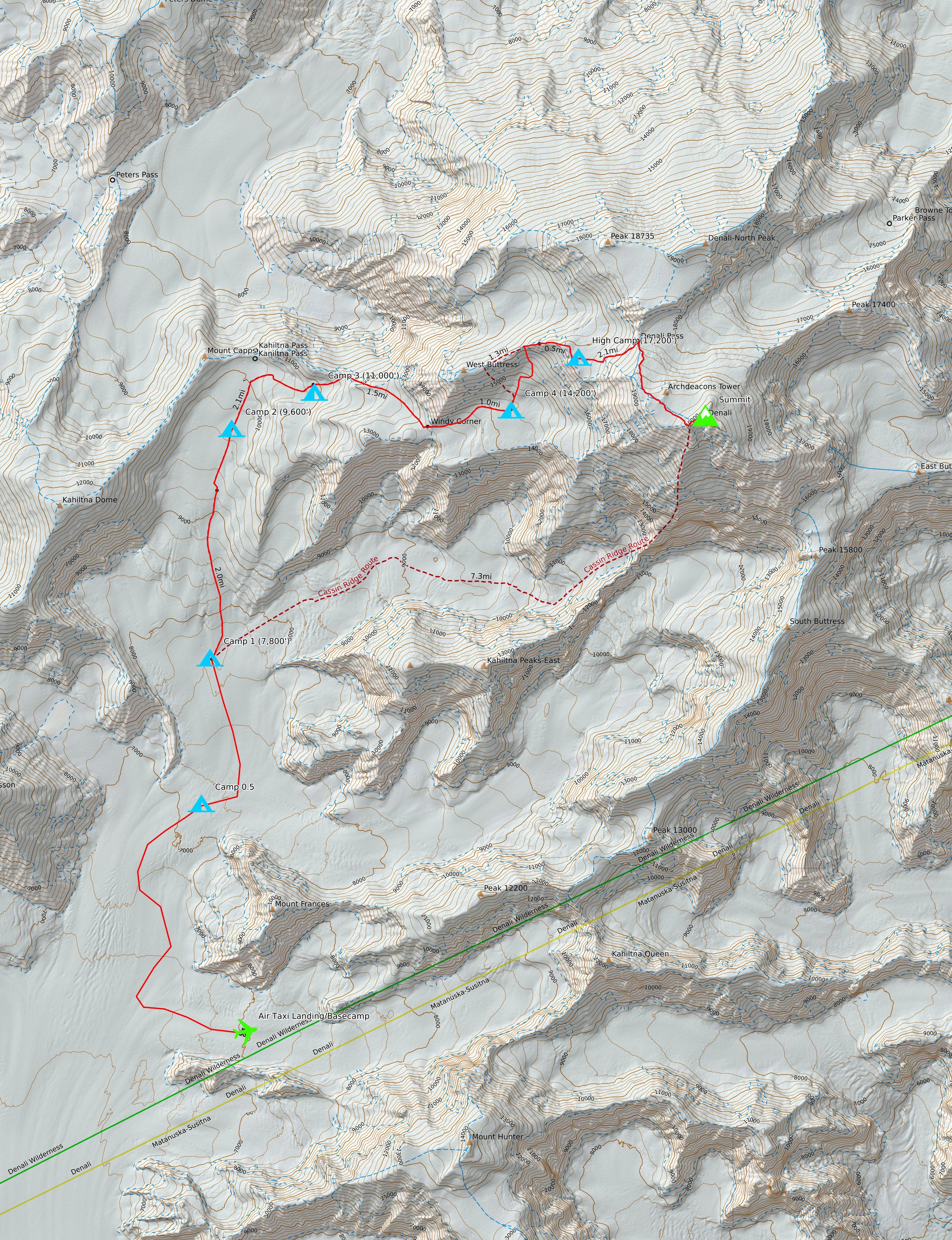
The route gains nearly 14,000’ over 16 miles from basecamp to summit. Teams typically use a total of five camps as they work their way up. Due to severe weather at the beginning of our trip, we were forced to add a sixth camp: “Camp 0.5” partway to Camp 1.

The climb took 15 days total: 13 days to the summit, and only two to return all the way to basecamp. The way up consisted of single carries (moving all of camp in one day), double carries (moving camp across two days, involving a cache run), and the occasional rest or weather day.

Loading the air taxi in Talkeetna.

Ridgeline above basecamp, flying in.

Traveling through the whiteout on day 1.

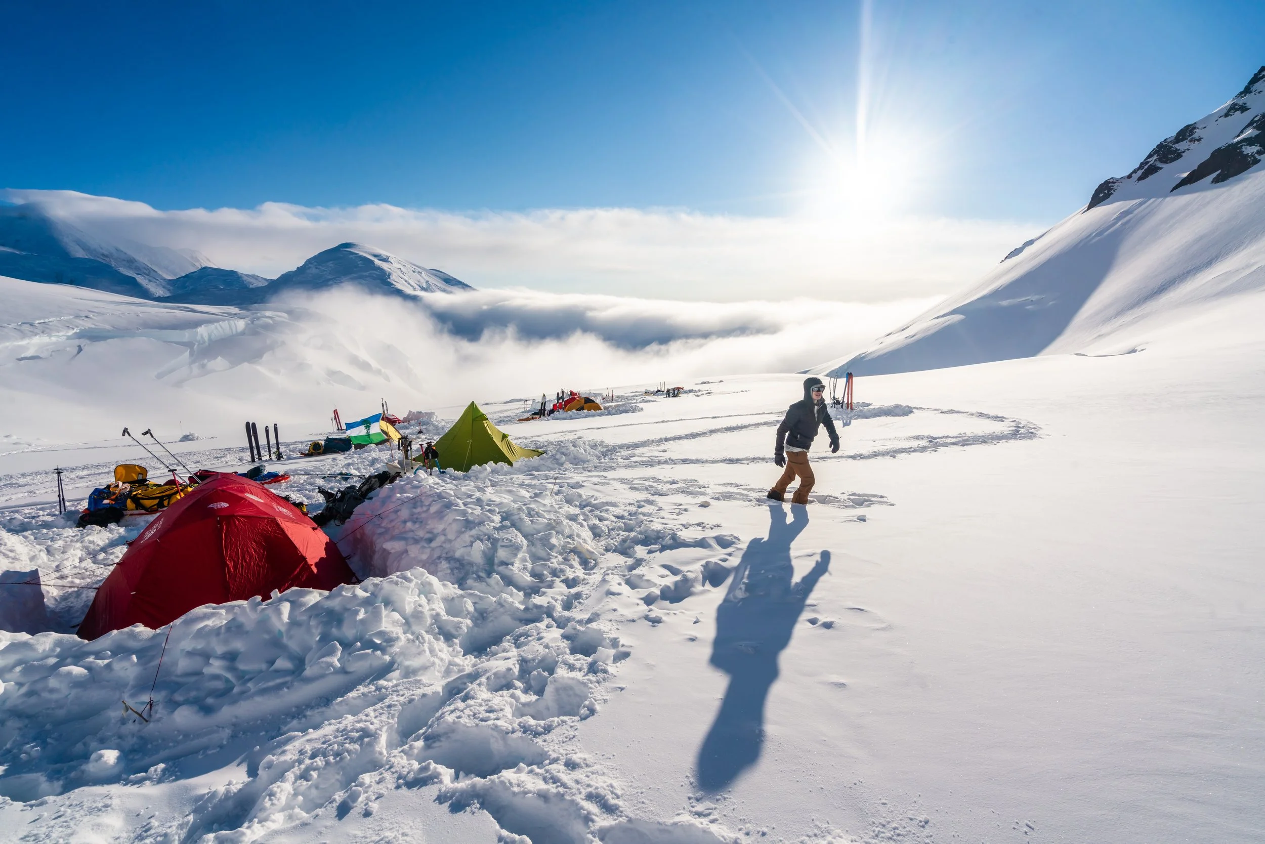
Packing up camp in the wind, partway to 7800' camp.

Setting up camp in a snowstorm.

Winds tearing across the lower glacier, slowly burying our tent in snow.

Setting up the cook tent at 7800'.

Digging out the tent with the summit in the background (left).

Setting up the cook tent at 7800'.

Digging out an entrance to the cook tent at 7800'.

Braving the wind during a "rest" day at 7800'.

View of the summit from 7800'.

Mt. Hunter as seen from 7800' camp.
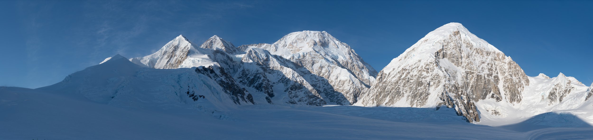
Denali (center), Kahiltnas West (right), route continues up glacier to left.

On the way up to 11000' camp.
Low sun at 11,000' camp.

Descending Squirrel Hill after a cache run to 13,200'.

Rounding Windy Corner after a cache run to 13,200'.

Mt. Foraker and Kahiltna Dome as seen from 11,000' camp (taken nearly at midnight).

On the way up to Windy Corner, moving camp.
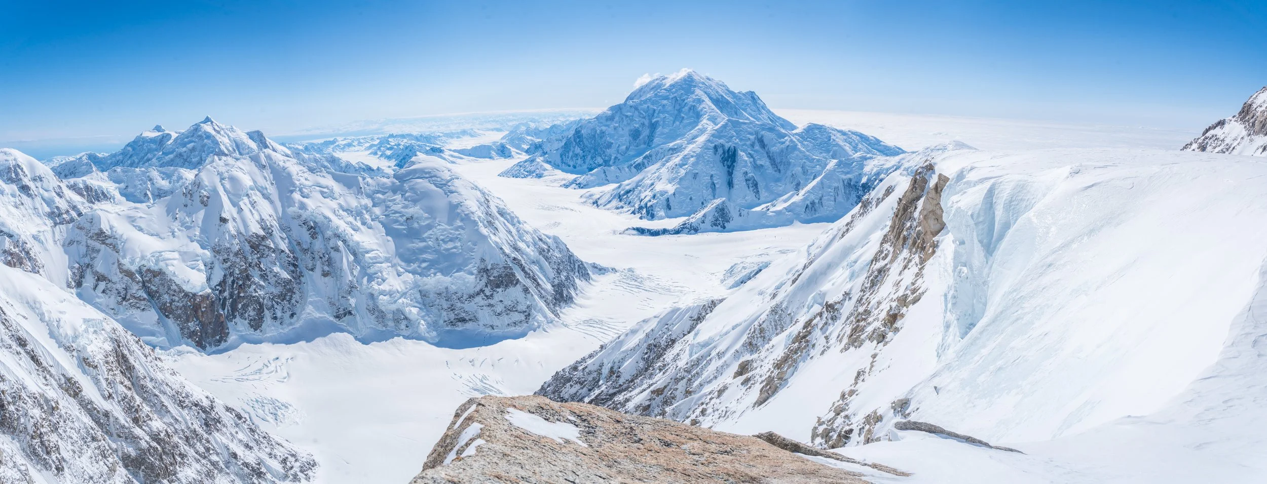
View from "Edge of the World" - Foraker (center), Hunter (left).
Sam on 16k ridge with Foraker.

Sam on the 16k ridge.

Sam on the 16k ridge with Foraker in the background, 14k camp bottom left.

Summit ridge, 20,000'.

Summit selfie!

Descending summit ridge.

Sam on the 16k ridge with Foraker in the background.

Descending 16k ridge with Foraker.

Sam on a section of fixed lines on the 16k ridge.

Packing for a longer expedition requires lots of gear - nearly 200lbs each. To break up the load, most of the weight was carried in custom-built sleds, and the rest in our packs. We brought 26 days worth of food and 3.5 gallons of fuel to ensure we had enough to make it up and down with resources to spare in case of an extended storm.
Day-by-Day
-
Day 1: (4mi, 7000’-7100’) Fly into basecamp from Talkeetna. Single carry from basecamp to Camp 0.5, forced to stop due to complete whiteout conditions.
Day 2: (2mi, 7100’-7800’) Single carry from Camp 0.5 to Camp 1. Broke trail through multiple feet of fresh snow.
Day 3: (0mi, 7800’) Weather day at Camp 1 due to extreme winds. Spent day resting in tent with the occasional break to dig ourselves out from accumulating snow.
Day 4: (5mi, 7800’-9600’-7800’) Cache run to Camp 2. Brought up lots of food and fuel, buried it, then skied back down to Camp 1.
Day 5: (2.5mi, 7800’-9600’) Moved up to Camp 2. Day started out nice but became full whiteout as we arrived at camp.
-
Day 6: (1.5mi, 9600’-11000’) Single carry to Camp 3.
Day 7: (4mi, 11000’-13500’-11000’) Cache run to 13500’ just around Windy Corner.
Day 8: (2.5mi, 11000’-14200’) Move up to Camp 4. Weather started out nice but deteriorated to severe wind storm as we rounded Windy Corner. Type 2 sort of day.
Day 9: (0mi, 14200’) Rest day at Camp 4. Toughed out strong winds in the morning to build camp, worked through the day.
Day 10: (2mi, 14200’-13500’-14200’) Retrieved cache from 13500’.
-
Day 11: (2mi, 14200’-16100’-14200’) Cache run to 16k ridge. Out of 14k camp and up the fixed lines to just above the col.
Day 12: (2mi, 14200’-17200’) Move up to High Camp. Fixed lines to 16000’, then 16k ridge up to camp.
Day 13: (5mi, 17200’-20310’-17200’) Summit day. Up the Autobahn right out of camp to Denali Pass, then along upper glacier, past the Archdeacon’s Tower, and up to the summit ridge, arriving at the true summit at 4:17pm. Return to High Camp that night.
-
Day 14: (14mi, 17200’-7800’) Descend from High Camp all the way to basecamp in one push. Over 12 hours of travel, arriving at basecamp past midnight.
Day 15: (57mi, 7800’-300’) Fly out of basecamp to Talkeetna.
THE LOWER MOUNTAIN
The air taxi drops climbers off miles from the actual base of the mountain, so the climb begins with days of approaching. The mountains of the Alaska Range tower above you as you cross the vast fields of snow and ice. The higher up the mountain you go, the steeper and more varied the terrain becomes.

Weather on Denali is one of the greatest challenges climbers face. Temperatures can swing from 80°F in the sun to -30°F when a system moves in. Winds in excess of 100mph have been recorded mid-mountain; these can devastate camps and wind chill can rapidly accelerate the effects of frostbite.
THE 16K RIDGE
To reach the upper mountain, climbers must first navigate the “16k ridge”: a dramatic stretch of snow and rock that gains over 1,000’ in merely half a mile. Before they can climb the ridge itself, however, climbers must ascend nearly 500 feet of steep, bulletproof alpine ice with the aid of fixed ropes.

Denali lies at a much higher latitude than many of the other high altitude peaks in the world. The Earth’s atmosphere thins as latitude increases, thus the altitude has a greater effect on climbers than it would in more equatorial ranges like the Himalaya. The effective available oxygen at the summit is less than half that at sea level. Every step at that altitude takes effort.
THE SUMMIT RIDGE
Looming above the large flat area at 19,500’ known as the “Football Field”, the summit ridge begins at 20,000’ just west of the true summit. A quarter mile along a knife edge ridge of snow brings climbers to the true summit at 20,310’.
SUMMIT 360°